Evidence over hype
Amazon LiDAR Primary Sources: Orellana, Carvajal, and Ancient Earthworks
Amazon LiDAR is trending because it seems to reopen an old question: did 16th-century witnesses describe real dense Amazon societies, or were they exaggerating? Here is the primary-source trail.
Source trail
Claim → sources → boundary
2026 LiDAR study
Supports the broader idea of engineered precolonial landscapes in parts of Amazonia.
Carvajal’s narrative
Useful as a sixteenth-century eyewitness account, but biased, limited, and not neutral.
What it proves
Makes dismissal harder. Does not prove fantasy claims or every dramatic detail.
Amazon LiDAR primary sources became interesting to me for a simple reason: the internet is moving faster than the evidence.
I kept seeing the same pattern. A new LiDAR study comes out. Headlines start talking about a lost Amazon civilization. People start asking whether the old Spanish eyewitnesses were telling the truth. Then the whole thing gets pulled toward El Dorado, the Lost City of Z, aliens, Ancient Apocalypse, all the usual internet gravity wells.
The better question is smaller and more useful:
What do the sources actually prove?
The short version is this. The new LiDAR evidence does not prove every dramatic claim in Gaspar de Carvajal’s 1542 account of Francisco de Orellana’s voyage down the Amazon. But it does make one old assumption harder to defend: that dense, organized, precolonial societies in parts of Amazonia were impossible.
That is where the story gets interesting.
Quick answer
If you are looking for Amazon LiDAR primary sources, start with the 2026 Nature LiDAR study, then compare it with Gaspar de Carvajal’s 1542 account of Orellana’s Amazon voyage. The LiDAR evidence supports the broader idea that parts of Amazonia had dense, engineered precolonial landscapes. It does not prove El Dorado, aliens, or every detail in Carvajal’s account.

Source: Wikimedia Commons. Geoglyphs on deforested land at the Fazenda Colorada site in Acre, Brazil.
What did LiDAR reveal in the Amazon?
The 2026 Nature study, “Over 20,000 precolonial earthworks in the Southwest Amazonia”, used LiDAR data over 4,430 kilometers of flight to map geometric earthworks hidden by vegetation.
The researchers reported 396 newly detected earthworks in the surveyed area. Then they estimated that the broader cultural area could contain 24,000 to 30,000 structures.
That is the part that made people stop scrolling.
Scientific American framed it as hundreds of ancient earthworks that had never been seen before. New Scientist pushed the bigger implication: a “lost civilisation” in the Amazon may have numbered as many as 3 million people.
That number matters. But it needs a leash.
It is not a census. Nobody counted 3 million people. It is a model based on earthworks, settlement assumptions, labor estimates, and how people may have been distributed across a large cultural area.
Still, even with that caution, the evidence points in a serious direction. Parts of Amazonia were not empty wilderness before Europeans arrived. People lived there, organized land there, built there, moved through connected landscapes there.
What are Amazon earthworks and geoglyphs?
Earthworks are human-shaped features in the landscape: ditches, mounds, embankments, roads, causeways, platforms, and geometric forms.
Geoglyphs are large shapes made on the ground.
In Acre and nearby parts of southwestern Amazonia, archaeologists have found circles, squares, roads, and other geometric structures. Some may have had ceremonial or social uses. Some may connect to settlement networks. Some may be part of a larger pattern we still do not fully understand.
This is why the word “city” gets tricky.
If someone says “Amazon city,” most readers picture stone buildings, walls, temples, and streets. That is probably the wrong mental image. A better phrase is low-density urbanism: organized human landscapes that do not look like compact European cities, but still show planning, labor, movement, ceremony, and social organization.
Less cinematic. More accurate.
Who were Orellana and Gaspar de Carvajal?
Francisco de Orellana was the Spanish explorer whose expedition traveled down the Amazon River in 1541 and 1542.
Gaspar de Carvajal was a Dominican friar who traveled with him and wrote an account of the journey, usually known in Spanish as the Relación or Descubrimiento del río de las Amazonas.
Carvajal’s account is one of the key primary sources for Orellana’s voyage. It is also messy.
And that matters.
He was not a neutral modern observer. He was part of a violent Spanish expedition. He was writing inside conquest, fear, hunger, religious language, politics, and survival. If we treat his account like a clean scientific report, we are reading it badly.
But if we throw it away completely because it is colonial, we are also reading it badly.
The source is useful because it is difficult. You have to handle it carefully.

Source: Wikimedia Commons. Map showing Francisco de Orellana’s Amazon River voyage from 1541 to 1542.
Did Carvajal really describe cities along the Amazon?
Yes, but “cities” needs careful handling.
In one section of Carvajal’s account, the expedition reaches the territory of Omagua. The Spanish text describes “muchas y muy grandes poblaciones,” meaning many very large settlements. It says the party passed through populated territory all day and later through the night. Carvajal also describes roads leading inland from one settlement and says the land appeared more populated as they traveled.
In another section, titled “Grandes Poblaciones” in the digitized Spanish text, Carvajal says the territory of Machiparo stretched for more than eighty leagues, with little distance between populated places. He describes one town as stretching five leagues without a break from house to house.
That is exactly the kind of passage people argue about.
If you read it literally, it sounds almost unbelievable. If you read it as frightened conquest testimony from men traveling under attack, there may be exaggeration. But if you compare it with modern evidence that large parts of Amazonia were managed, settled, engineered, and connected by roads and earthworks, it becomes harder to dismiss the whole thing as fantasy.
That does not mean Carvajal was “proven right.” It means the lazy version, “he must have made it all up,” is weaker now.
Was Carvajal lying, exaggerating, or partly right?
Probably partly right, partly limited, and probably exaggerated in places.
One obvious objection is that conquistadors exaggerated all the time.
Fair.
Expedition accounts could be shaped by fear, hunger, violence, misunderstanding, religion, and the need to justify conquest. That is not a small problem. It is baked into the source.
But the opposite mistake is also a problem. For a long time, some readers assumed rainforest environments could not have supported dense populations or complex societies. That assumption looks weaker now.
So I would not ask, “Was Carvajal completely right?”
I would ask this instead:
Which parts of Carvajal’s account are supported, contradicted, or still unanswered by modern evidence?
That is the primary source way to read a claim.
How many people lived in the pre-Columbian Amazon?
The Nature paper proposes that the Aquiry cultural area may have had a population of 1.25 to 3 million people around AD 100 to 300.
That is the number powering a lot of the headlines.
But again, it is not a direct observation. It depends on assumptions:
- how many earthworks existed,
- how many people were needed to build and maintain them,
- how long they were used,
- whether sites were occupied at the same time,
- how settlements were distributed around ceremonial centers.
So no, “up to 3 million” does not mean one giant Amazon city. It means a model-based estimate for a large cultural region.
The number may be plausible and important. It should still be treated as evidence-based interpretation, not a final headcount.
How can LiDAR find structures under rainforest?
LiDAR stands for light detection and ranging.
An aircraft or drone sends laser pulses toward the ground. Some pulses pass through small gaps in the canopy, bounce off the terrain, and return to the sensor. Researchers can then model the ground surface beneath vegetation.
LiDAR does not magically photograph buried artifacts. It reveals shapes in the landscape: ditches, mounds, roads, geometric forms, platforms, and terrain changes.
Those patterns still need interpretation. Often, they also need fieldwork.
This also answers a common misconception: “Why can’t we just see this on Google Earth?”
Sometimes you can. Some deforested geoglyphs are visible in satellite images. Others are hidden under canopy or only become clear when LiDAR strips away the vegetation layer digitally.
Could people farm in Amazon rainforest soils?
Another common question is whether the Amazon could support millions of people at all.
The old simplified version goes like this: rainforest soils are poor, therefore dense societies were impossible.
Too simple.
Archaeologists and environmental historians have shown that Indigenous peoples shaped parts of Amazonia through managed forests, river resources, agroforestry, fish, floodplains, cultivated plants, and anthropogenic dark earth often called terra preta.
These were not untouched wilderness landscapes. They were lived-in environments.
What happened after European contact?
The timeline matters here.
Some structures discussed in the recent LiDAR coverage date roughly from 600 BC to AD 850, especially in relation to the Aquiry civilization. Orellana and Carvajal traveled in the 1540s. Those are not automatically the same people at the same moment.
Still, later Amazonian societies suffered massively after European contact. Disease, violence, enslavement, mission systems, forced movement, trade disruption, and colonial pressure reshaped the region.
That helps explain why later explorers often saw fewer people than early accounts described.
Depopulation can explain part of the contradiction. If settlement systems collapsed or reorganized after contact, later observers would not necessarily see what an earlier expedition saw.
Is this the Lost City of Z or El Dorado?
No.
The Amazon LiDAR discoveries do not prove El Dorado, the Lost City of Z, aliens, Atlantis, or a suppressed hyper-advanced civilization.
Honestly, that version is less interesting anyway.
The real story is better: Indigenous Amazonian societies built large, organized, engineered landscapes before European colonization. That does not need treasure myths to matter.
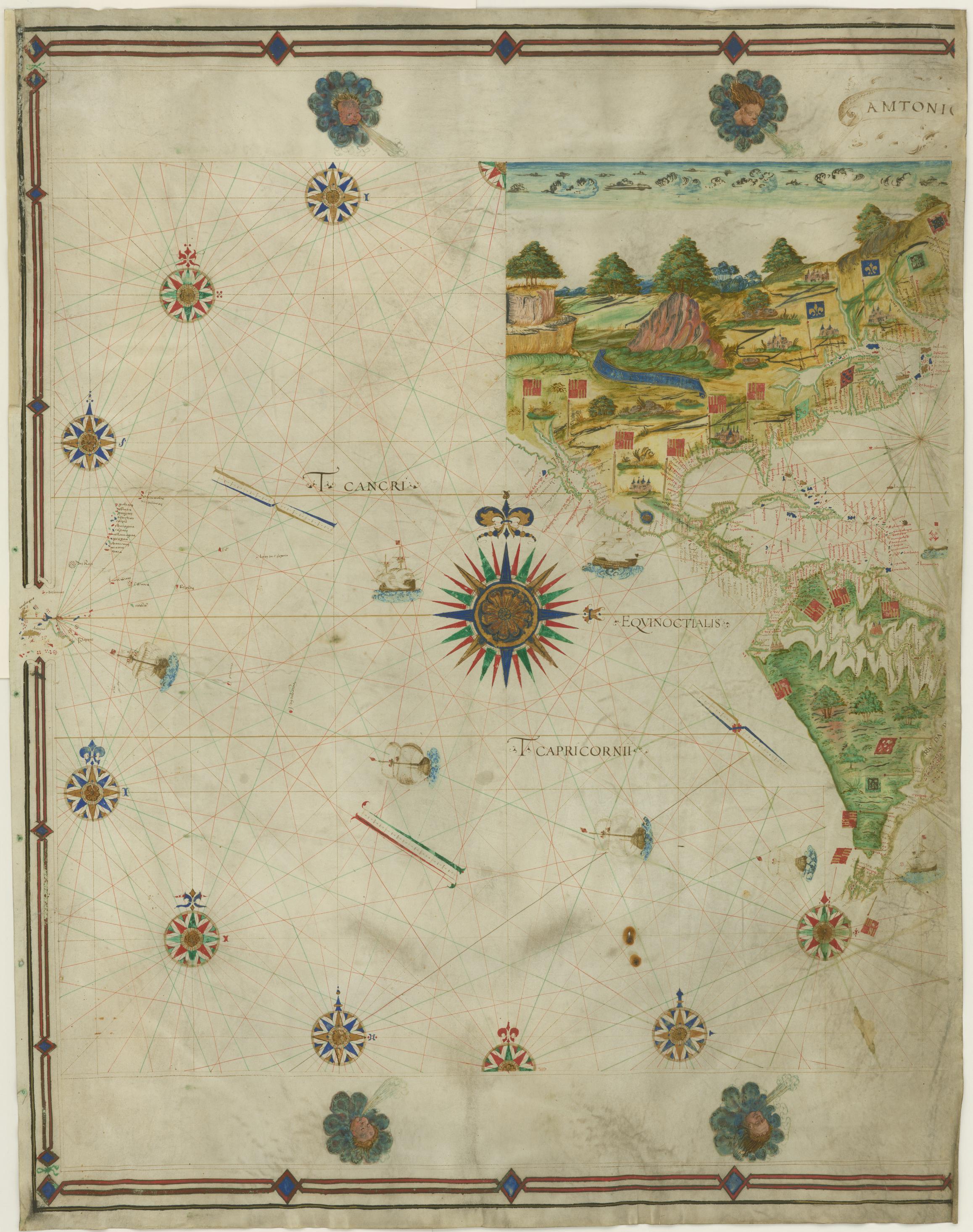
Source: Wikimedia Commons. 1546 map recording Francisco de Orellana’s journey across South America and down the Amazon River.
Amazon LiDAR primary sources and evidence trail
If you want to check this topic yourself, separate the sources by type.
Modern scientific study:
Public science coverage:
- Scientific American, “Hundreds of never-before-seen ancient earthworks discovered in the Amazon”
- New Scientist, “Lost civilisation in the Amazon may have numbered 3 million people”
Early expedition account:
- Internet Archive edition of Descubrimiento del río de las Amazonas según la relación... de Fr. Gaspar de Carvajal
- Digitized Spanish excerpts from Carvajal’s account, including Omagua and Grandes Poblaciones
How to read them together:
- Start with the claim: “LiDAR proved Carvajal was right.”
- Check what Carvajal actually wrote.
- Check what the LiDAR study actually found.
- Separate direct proof from supporting context.
- Ask what remains uncertain.
Good history is not finding one source that agrees with you. It is knowing what the source can actually prove.
FAQ
Did LiDAR prove Gaspar de Carvajal was right?
Not completely. The LiDAR evidence supports the broader idea that parts of Amazonia had dense, engineered, precolonial landscapes. It does not prove every scene or number in Carvajal’s account.
Can LiDAR see through trees?
LiDAR can send laser pulses through gaps in the canopy and produce a ground model beneath vegetation. It does not literally see every object under the forest.
Are Amazon earthworks the same as cities?
Not always. Some may be ceremonial centers, roads, geoglyphs, settlement features, or parts of low-density urban networks. “City” can be useful shorthand, but it can also mislead.
Is this evidence for El Dorado or aliens?
No. It is evidence for complex Indigenous Amazonian societies and landscape engineering. That is already historically important without adding fantasy claims.
Why this matters for primary-source research
This is why I like the Amazon LiDAR story as a research example.
A viral headline can say “lost civilization discovered.” A comment section can ask whether explorers were telling the truth. A documentary can push the mystery angle. But the actual work is slower and better:
- read the old account,
- read the modern study,
- compare what each source can prove,
- separate evidence from interpretation.
That is the habit I built PrimarySourceFinder for.
If you want to work through this specific example, start with the Amazon LiDAR source finder. It gives you the source trail first: the LiDAR study, Carvajal’s account, Orellana context, and the evidence boundaries around each claim.
If you want to test a historical claim like this yourself, create a free PrimarySourceFinder account and find the primary sources behind your own topic.
Frequently asked questions
Did LiDAR prove Gaspar de Carvajal was right?
Not completely. The LiDAR evidence supports the broader idea that parts of Amazonia had dense, engineered, precolonial landscapes. It does not prove every scene or number in Carvajal's account.
Can LiDAR see through trees?
LiDAR can send laser pulses through gaps in the canopy and produce a ground model beneath vegetation. It does not literally see every object under the forest.
Are Amazon earthworks the same as cities?
Not always. Some may be ceremonial centers, roads, geoglyphs, settlement features, or parts of low-density urban networks. City can be useful shorthand, but it can also mislead.
Is this evidence for El Dorado or aliens?
No. It is evidence for complex Indigenous Amazonian societies and landscape engineering. That is already historically important without adding fantasy claims.
Find the primary sources behind any historical claim
Search any topic and get the most relevant primary and secondary sources, ranked by historical importance, with free copies wherever they exist online.
Find sources for your topic